SUBMITTED BY HENRYTYE GLAZEBROOK, U of S COMMUNICATIONS
Pardon the pun, but Canada is practically overflowing with fresh water. And believe it or not, that abundance causes problems for water researchers.
“Canada is blessed with more fresh water than anywhere else in the world, but there’s no way you can put sensors in to monitor everything,” said Al Pietroniro, P.Eng., executive director of National Hydrological Services, an adjunct professor with the University of Saskatchewan and member of the Centre for Hydrology. “It’s too big.”
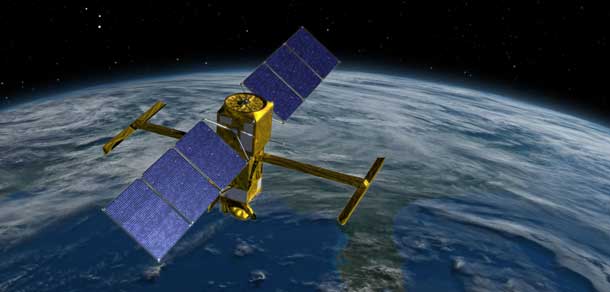
It’s this exact issue that SWOT (surface water and ocean topography) is aimed at solving. The term refers to a satellite scheduled to launch in 2021 by the National Aeronautics and Space Agency (NASA). SWOT will be capable of measuring surface elevations of any water body large enough for its sensors to collect data on, including the vast majority of Canada’s seemingly infinite northern lakes and rivers.
Water surface elevation is relatively simple information to collect, requiring only limited tools and small teams to venture out to a site and gather measurements. The problem, however, is the time and costs required to make such trips feasible over Canada’s vast landscape. SWOT, if successful, will blow the doors open on the breadth of available data.

“All of a sudden, data that’s only accessible on a 3 or 5 or 10-day basis at a few locations is now available immediately and everywhere, and it’s pretty cost effective in that the satellite would already be up,” Pietroniro said. “That changes, from an operational perspective, what you would actually be looking at. It changes what you’d be offering as a service to Canadians.”
The project entered its first phase of calibration and validation on July 7, involving a series of sites chosen around the globe at which partner institutions have set up teams and equipment to collect data that can be measured against numbers taken from flyover airplanes (AirSWOT)—designed to mimic eventual SWOT data sourcing—in order to cross- reference accuracy.
“There’s not a lot of data sitting out there and so these calibration sites are designed for us to find out the best way to make sure the satellite is seeing what it’s supposed to see and measuring exactly as it’s supposed to be measuring,” Pietroniro said.
The U of S—one among a list of collaborators including NASA and the NASA Above Programme, Canadian Space Agency, Centre national d’études spatiales, NASA’s Jet Propulsion Laboratory, Environment and Climate Change Canada, University of North Carolina, University of California Los Angeles and other researchers—has established data collection sites along the North Saskatchewan River, at Redberry Lake and the St. Denis National Wildlife Area.
Pietroniro, referring to the North Saskatchewan River site as one of the project’s “key global sites,” said the U of S is uniquely positioned to be a leader during the initiative, thanks to its robust water research programs including the Global Institute for Water Security, Global Water Futures and three American Geophysical Union Fellows, Howard Wheater, Jeff McDonnell and John Pomeroy.
“The U of S has peaked at this point with John and Howard and Jeff as examples and there’s a lot more people with the Toxicology Centre and SENS (the School of Environment and Sustainability), to name a few,” he said. “They’re not only probably the most influential water resources group in Canada, they’re globally probably the most influential as well.”
The SWOT project is still in early stages, but already Pietroniro is excited about the potential applications on everything from ephemeral prairie sloughs to permafrost level calculations and water balance calculations once all the kinks are worked out and it launches in earnest.
“Every reservoir in North America is going to be measurable, all the big ones and most of the lakes and rivers,” he said. “How does that change how we deal with water management in this country? That data’s really not always available, so that changes so much in terms of what we’re doing.
“I don’t like using the phrase lightly, but I think it is a paradigm shift. It has the potential to really change how we can manage water in this country.”
The Global Institute for Water Security
At the University of Saskatchewan’s Global Institute for Water Security (GIWS), sustainable use of the world’s water resources and protection against natural hazards such as flood and drought are key priorities.
GIWS is co-located with Environment Canada’s National Hydrology Research Centre at Innovation Place and funded through the Canada Excellence Research Chair (CERC) in Water Security, a $30-million, joint federal-provincial-university commitment over seven years. Led by Dr. Howard Wheater, one of the world’s foremost hydrologists, the institute is developing the modelling tools, techniques and policies to sustainably manage the world’s freshwater resources.
Officially launched in March 2011, the institute builds upon leading expertise and capacity in water research at the U of S. At GIWS, faculty and government scientists work with students and post-doctoral fellows on interdisciplinary teams to understand how climate change, land management practices and the development of natural resources affect the water environment and to develop the improved modelling tools needed to sustainably manage water. GIWS combines expertise in natural sciences, engineering and the social sciences, recognizing that people and their activities are of critical importance for water science and management.
While the institute’s work addresses water issues worldwide, an important focus is on Western Canada. It is developing the Saskatchewan River Basin as a high-quality observatory with state-of-the-art monitoring of the Canadian Rocky Mountains, boreal forest and prairies. Its research teams are improving our ability to predict river flows and understand how water quality and river basin ecosystems respond to climate change. Through its socio-hydrology research, the institute goes beyond traditional water resources management to integrate humans and their activities into water science and ensure that water decision-making incorporates a range of values and perspectives about the meaning, value and use of water. Its researchers hold workshops and activities throughout the river basin to talk to those engaged in the management of water resources, understand their concerns and what scientific tools are needed to foster water security on the Prairies and beyond.
The GIWS Mission
Create a focus and platform for interdisciplinary collaboration that recognizes the societal dimensions of water security, human impacts on the environment and the linkages and feedbacks between atmosphere, land and water systems. This requires new integration of the relevant spectrum of natural, health and social sciences, public policy and engineering;
Develop the knowledge, science and technologies needed to support integrated water quantity and quality management in the face of uncertain climate and water resource futures and address local, regional and global water security agendas;
Develop partnerships with key stakeholders to translate science into policy and management support to meet water security challenges, including interactions among water, food, energy and ecosystem services (i.e., benefits to human welfare), climate change adaptation and mitigation challenges and the human health agenda;
Provide tools, technologies and computer models for application to key globally significant water security issues, with international application; and,
Create a unique opportunity for governments, industry and universities to invest in and collaborate on one of the most pressing global issues.